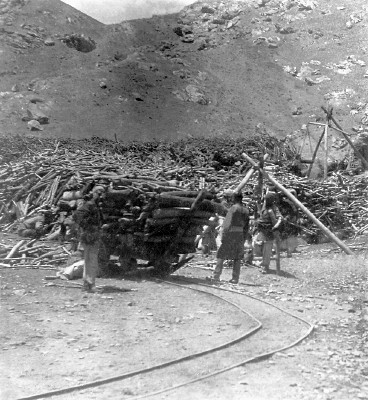
Photo taken by Emil Rybitschka, used courtesy Paul Bucherer-Dietschi phototheca-afghanica.ch (ref ER488)
There was a narrow gauge railway to bring wood for the steam engines at the Mashin Khana factory from Chahardeh, the valley of four villages to the southwest of Kabul. This photograph taken by the Austrian officer Emil Rybitschka in 1915-19 shows the end of the line at the wood yard at the Mashin Khana.
This may well be the same as the narrow gauge railway which, for at least part of its length, ran down the middle of a road alongside the Kabul River. It was in existence in 1904, but so far the only information about this line that I have found comes from three almost identical photographs at the British Library.
The pictures were taken by Major Robert Bird (1866-1918) of the Indian Medical Service, who was deputed to Kabul to attend the Amir of Afghanistan Habibullah in 1904. They show just a few feet of the railway.
The captions say:1
- Photo 430/84(79) Road by Kabul River, beyond the workshops. Note the tramway to Chardchi – Cabul river through the trees – tail of Asmai Heights.
- Photo 430/84(125) Road by Cabul River beyond the workshop. Tramway in foreground.
- Photo 430/84(126) Road to *** by Cabul River. Tramway. [*** is illegible]
Unfortunately these photos are not (as far as I am aware) available online anywhere, so to see them you will need to make an appointment at the British Library.
The three photos were all taken from the same spot, and probably at the same time. They show horses and donkeys carrying loads and people along a road, including a woman with a child on a horse. What appears to be the same person is in both photo 79 and photo 125.
Sticking up in the centre of the road are some rails. Only a single track is visible, but of course there could be a second track out of shot. The road looks well maintained, but it hard to tell what the surface it. I would estimate that the railway is perhaps around 18” gauge, 2ft at the most.
The hard-to-read place name looks like it might be Indeptai, or perhaps Indebbe which is mentioned in the caption to another photo, number 76, which shows “Chouki on road to Indebbe just past the factory”.
I would assume “the workshops” refers to the Mashin Khana factory site. Asmai Heights is what is now (but presumably not in 1904!) popularly known as TV Hill from the broadcasting masts on top of it, and is not far away from the workshops.
However I can’t spot any places on maps of Kabul which have names that look like a British visitor in around 1904 might spell them as Chardchi and Indeptai. Has anyone got any ideas? There is Pul-e-Charkhi, with its prison, but that appears to be on the other side of the city to the workshops, and not by the river.
There are no obvious landmarks in the photos to help pin down the location. The road is lined with trees, with the river visible through them. Nothing is visible across the river, because the photos are over-exposed.
Any more information about this railway or the locations of Chardchi and Indeptai would be gratefully received.
A separate line ran in the other direction, to the northeastern hillocks behind what is now the airport, to get stone for building.
The Amir of Kabul has ordered a survey to be made for a steam tramway, five miles in length, outside Kabul City, in order to bring stone for building purposes from the adjacent hills.
Source: News of the Week, p7, The Liberal and the New Dispensation, 9 July 1893
A similar report also appears in Electric Railway Review, Volume 3, 1893.
References
- Curzon Collection: Views of Afghanistan and the North-West Frontier. Series of small printing-out paper prints originally contained in an envelope labelled ‘For Lord Curzon. Set of snap-shots taken by Major Bird on the way to and at Kabul.’ British Library shelfmark Photo 430/84. Viewed by me on 7 March 2014 ↩