Map of the country between Sind and Candahar showing the course of the proposed Railway

The Frontier Clasp and its Railways

…the British Indian government had just started making inroads to the Khyber Agency by extending it’s railway beyond Jamrud.

The Peshawar – Jamrud railway had already been constructed on which the “Flying Afridi” train service would make a trip once a day. This train service, part of the greater Kabul River Railway or the Loye Shilman railway project, was to be extended much deeper into the Khyber Agency. The initial survey by Captain Macdonald was to follow the upstream right banks of the River Kabul along the Loye Shilman territory till the village of Palosi on the Afghan border. Although less challenging, this route was scrapped due to political issues of the time with the then Amir of Afghanistan, Amir Habibullah Khan and also probably due to the sheer number of bends in the River along the route.
Source: The Frontier Clasp and its Railways, Omar Usman, Khyber.org, 2011-03-14

There is a map which shows the Kabul River railway.

China to Afghanistan via Tajikstan

Zeitschrift der OSShD is a magazine published six times a year in German, Russian and Chinese versions by OSJD, the Organisation for Co-Operation between Railways. The 2/2011 (316) issue has an article (pp1-6) “Tadjik steel railway lines – conquering the mountain peaks” by Amonullo Hukumatullo, head of Tajikistan’s national railway Rohi Ohani Tojikiston. It gives an overview of the railway company, and includes some information about proposed rail links to Afghanistan.

A map accompanying the OSJD article shows a proposed railway from Kashgar (Kashi) in China to Afghanistan. From Kashgar the line runs though Sary-Taşh in Kyrgyzstan (from where a branch would run north to Osh), crossing the Kyrgyzstan/Tajikistan border near Карамык (Karamyk), meeting the existing line from Душанбе (Dushanbe) at Иляк (Ilyak?) a short distance southeast of Ваҳдат (Vakhdat), then running to Яван (Yavan?), and onwards over a line which is currently under construction1 to reach Курган-Тюбе (Kurgan-Tyube, and countless other romanisations).

Leaving the existing Uzbekistan to Kurgan-Tyube line at Джалоліддіна Румі (Jaloliddina Rumi) a new 59 km line costing USD73.2m will run to the Tajik border post at Нижний Пяндж (Nizhniy Panj, which is the Russian name; it’s Панҷи Поён (Panji Poyon) in Tajik).

(There was once a 750 mm gauge line on this section of the route, built in 1929-31 and opened in early 1932 but closed in the 1990s.2 In 2007 a road bridge was opened over the river Amu or Panj Darya which forms the Tajik-Afghan border, called – inevitably – the “Bridge to Friendship”.)3

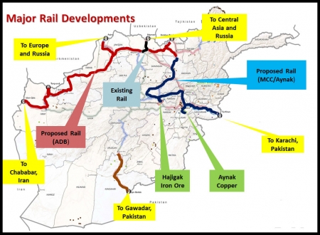
The map shows the railway entering Afghanistan at Shirkhan Bandar, and continuing to Kunduz. From Kunduz proposed lines are shown running south to Kabul and the Khyber Pass, with a spur to Aynak for the mine, and also west along the northern corridor to Mazar-i-Sharif, Herat and Iran.

There are the usual comments in the article about transit traffic, and how a line though Afghanistan would would mean [insert name]-stan would not have not send traffic though [next door]-stan in order to reach Iran. Tajikistan currently has three sections of railway, but they run east-west and are not interconnected with each other except through Uzbekistan, and there have been claims that Uzbekistan has been delaying Tajikistan-bound traffic.

The magazine article also discusses the gauge problem, coming down in favour of 1435 mm standard gauge for the China – Iran route, rather than the 1520 mm of the existing lines Tajikistan.

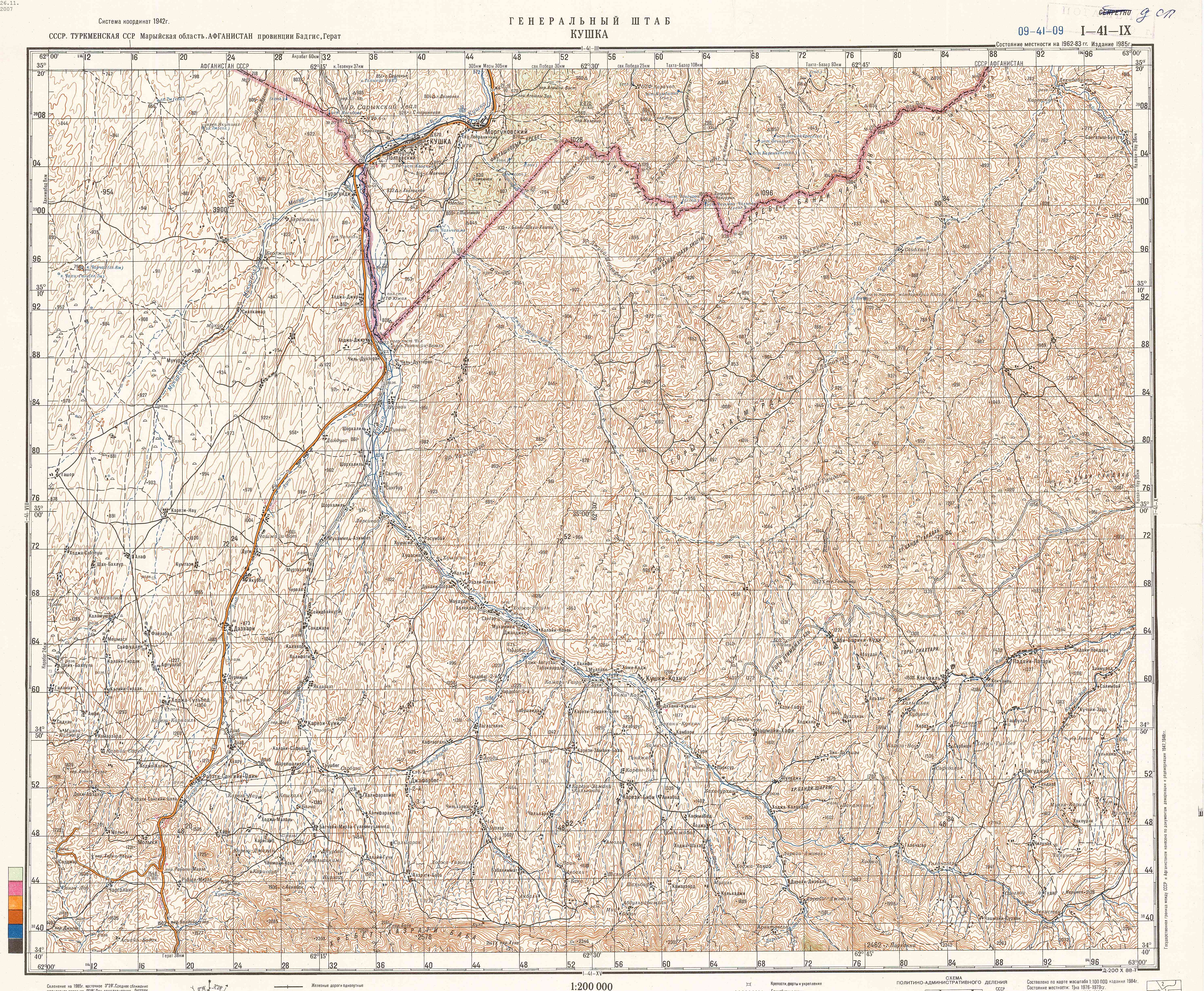
Here is a rough attempt at plotting the places in question on a map.


View China – Tajikistan – Afghanistan railway in a larger map

This posting is based on the German version of the OSJD magazine, because I can read a little German. However the place names in the magazine have gone from Cyrillic (and probably Russian rather than Tajik) to German romanisation, though the map itself is in Cyrillic. While I have tried to sanitise the names, they have possibly got mangled en route. No offence is intended if your favourite spelling has been missed! It doesn’t help that some places have changed their names over the years – while it’s perhaps no surprise that Stalinabad has disappeared from the map (it is now Dushanbe), it is less obvious that Kolkhozobod became Jaloliddina Rumi in 2007, in honour of a C13th poet.

Tajikistan is a bit of an information black hole – I can’t even find many photos of trains there, or an official railway website.

Back in January 2011, Hukumatullo told a news conference that more than 160 000 tons of freight were shipped to Afghanistan via Tajikistan in 2010: Since there is now direct rail link connecting Tajikistan and Afghanistan, the cargo was transported from the Tajik railroad station Kolkhozobod to the Afghan settlement of Sherkhan Bandar by vehicles.4 I suspect now should read no, and vehicles means road vehicles.

  1. Tajikistan: Rail Link to Afghanistan under Construction, 19 March 2009, www.EurasiaNet.org
  2. Road vs. Rail. A Note on Transport Development in Tadzhikistan, MV Hambly, Soviet Studies Vol. 19, No. 3 (Jan., 1968), pp. 421-425, Taylor & Francis Ltd
  3. News: Afghanistan, Tajikistan dedicate ‘Bridge to Friendship’, 3 September 2007, Combined Joint Task Force – 82 PAO, DVIDS
  4. More than 160,000 tons of cargo shipped to Afghanistan via Tajik territory, 20 January 2011, Payrav Corshanbiyev, ASIA-Plus news agency, Dushanbe

Maps of Afghan rail projects

The Ministry of Mines website now features a new photo gallery with some maps of proposed railways.

Map of major rail developments in Afghanistan

The National Resource Corridors map includes a Kabul to Kandahar railway “to be studied”. Historically this route was seen as a priority for developing a national rail network, but in recent years the focus has been on the more stable north of the country.

Map of national resource corridors in Afghanistan

The Regional Rail Networks map shows how things fit into the bigger picture. The Kazakhstan – Turkmenistan – Iran line paralleling the Caspian Sea appears to be absent, although recent news reports suggest part of it will open by October this year.

Map of railways in Afghanistan and surrounding countries

Narrow gauge railways in Tajikistan

Narrow gauge railway Dushanbe – Kurgan-Tube – Kulyab, Nizhniy Panj” – in Russian, but Google Translate works pretty well.

The 750 mm gauge railway network in the southwest of Tajikistan was started in 1929. Originally there were two unrelated lines: Kurgan-Tube – Nizhniy Panj…

Nizhniy Panj is on north side of the river which forms the border with Afghanistan. The railway closed in the 1990s, but there is some talk of building a new line in the area with a bridge to Afghanistan and onward connections to Kunduz, Mazar-i-Sharif and beyond.

There is also a link to a general history of railways in Tajikistan (in Russian).

Maps of planned Afghan rail projects

Asian Development Bank’s documentation on the 7th Ministerial Conference on Central Asia Regional Economic Cooperation held in Baku on 19–21 November 2008 includes a PDF with maps of the various railway proposals currently active in Afghanistan.

Railway Development Plans in Afghanistan (2.2 MB PDF), was a presentation by Dr Wali Mohammad Rasooli, Technical Deputy Minister, Ministry of Public Works, Islamic Republic of Afghanistan.

ADB supports railway study

A news release from the Asian Development Bank, dated 28 April 2009. ADB has also published Islamic Republic of Afghanistan: Railway Development Study (PDF), with some background and a handy map.

Boost for Afghan Plan to Develop Railway System

MANILA, PHILIPPINES – Afghanistan’s push to develop a railway system that will spur economic growth and make the country a key transit and trade route within Asia is to receive support from the Asian Development Bank (ADB).

ADB has approved a technical assistance grant of US$1.2 million to fund a feasibility study for two key railway routes in the north of the country. The focus will be on railway lines linking northern Afghanistan with neighboring Uzbekistan and Tajikistan.

Land-locked Afghanistan has seen major improvements in its road network in recent years, with support from ADB. However, only half the roads that connect 24 provinces in the country are serviceable throughout the year and the system remains inadequate, inefficient and, in some places, unsafe. Rail provides a more reliable and cost-effective option for moving people and goods, and can help Afghanistan unlock its significant mineral, industrial and agricultural wealth.

An expanded rail system will also help Afghanistan realize its strategic potential as a gateway linking Central, South Asia and the Middle East, and supports the Central Asia Regional Economic Cooperation (CAREC) group of countries’ transport corridors program.

“The technical assistance support for an expanded rail system will help boost sustainable economic growth and poverty reduction in the country, as well as fostering regional cooperation by boosting intra and interregional trade along the CAREC transport corridors,” says Manzoor Rehman, Senior Transport Specialist in ADB’s Central and West Asia Department. “It will enhance Afghanistan’s economic competitiveness and provide all-year accessibility to its neighbors.”

Feasibility studies will be carried out on two proposed railway lines linking Hairatan, on the border with Uzbekistan, to Herat, in west Afghanistan, and another starting at Shirkhan Bendar, on the border with Tajikistan, and traveling via Kunduz and Mazar-e-Sharif to Herat. ADB will assess long-term traffic demand, and the rail sector’s potential capacity, before making recommendations to the Government on the two routes.

The total project cost is estimated at $1.26 million with the government making an in-kind contribution equivalent to $60,000. The Ministry of Public Works will be the Executing Agency.

Since 2002, ADB has approved financial support of over $600 million for Afghanistan’s transport and communications sector, mostly for roads. This is over 40% of ADB’s overall assistance to the country and around 25% of all donor financing for Afghanistan’s roads. The new technical assistance grant is included in the ADB’s 2009 pipeline for nonlending products and services for Afghanistan, as set out in the ADB’s Country Partnership Strategy: Afghanistan, 2009-2013.
Source: Asian Development Bank 2009-04-28